View from High Rock on Quirauk Mountain

View from High Rock on Quirauk Mountain

Pages

Showing posts with label National Park. Show all posts

Thursday, June 18, 2015

Greenbelt Park

Greenbelt Park: Urban Oasis

Greenbelt Park sits just inside the Capital Beltway, and mostly located in between the BW Parkway (MD295) and Maryland Route 201. Open year round, the Park is a nice 'urban oasis' of nature, only a few miles from the nation's capital. In addition to picnic areas and almost 10 miles of hiking trails, Greenbelt Park also has 174 camping sites.

History

Long before colonial settlers appeared here, trees and flowers covered these rolling hills and wildlife roamed the woodlands. Algonquin Indians hunted this land in competition with other smaller tribes. A balance existed between the land and its plants, animals, and native people. Then the colonists arrived. Trees fell and forests gave way to farmland. Wildlife retreated to the frontier. For the next 150 years, people cleared the land, plowed the fields, and planted tobacco, corn, and other crops. The rich fertile soil returned high yields. The people did not give back to the land as much as they took. The land wore out, producing less each season and farming ceased. The land was left bare and defenseless. Erosion caused many scars before nature could slow the process with new growth. Since the early 1900's the land has been recovering. Today the mixed pine and decidious forest testifies to the land's ability to recover.
The land of Greenbelt Park was acquired by the National Park Service in 1950 under Public Law 643.
-http://www.nps.gov/gree/learn/historyculture/index.htm
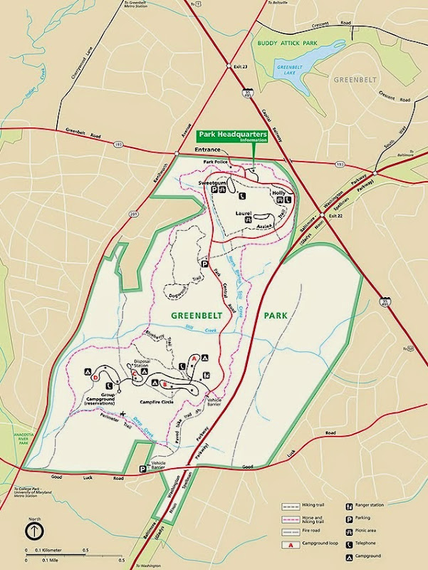
Perimeter Trail


As posted, the Greenbelt Perimeter trail is a 5.3-mile trail that circles the western portion of the park. The trail is mostly dirt and gravel, with some boardwalks and bridges over streams and runs. A couple more notes:

  • Difficulty: Easy to Moderate (due to length). There are rolling hills throughout the hike, but nothing challenging. I brought my trusty hiking stick, but didn't really need it for much of the hike. I wore running shoes, which worked fine, but I probably would have been better served wearing some kind of trail shoes.

  • Solitude: I only saw a few people during my hike (and except for a larger group toward the end, it would have been less than 10), so some of the "busy" factor you might have at other trails wasn't there. But, as always, this is subject to change. I hiked on Memorial Day weekend, and expected more people. I was pleasantly surprised.
    One unavoidable thing: for much of the hike, you'll probably hear a lot of noise from the highways on both sides of the park, especially 295. At times, you're hiking only maybe 20-30 yards from the either the Capital Beltway or BW Parkway, and that means traffic noise.

  • Blazes: The Perimeter is marked with a yellow blaze. However, the only time you really should have to pay attention to the blazes is at intersections (I'll make a note of this later).
  • Other:
  • There are restrooms at the Sweetgum Picnic area, which is where I parked. Otherwise, there are no facilities along the trail.
  • As always, bring some water and snacks with you.
  • There are benches placed sporadically along the trail. Great for taking a breather and having a snack. Unfortunately, they're a little too sporadic; you may go a mile without seeing one.
  • The perimeter trail is dog-friendly, so bring your furry friends along, on a leash of course.
  • No bicycles are permitted on the perimeter trail, but horses are permitted. I saw no sign of recent equine activity (i.e. no horse manure) so I'm not quite sure how often it's traveled by horses and riders.
  • Bug spray: There was a park warning in effect concerning ticks. Make sure you use bug spray and check yourself (and your furry friends) for ticks after you leave the trail.

Pictures

The trailhead, not far from the park entrance. I 'backtracked' from the Sweetgum Picnic Area to get back to the trailhead.

Note: Greenbelt Park comprises part of the American Discovery Trail which stretches from coast to coast across 15 states. There's a section of the ADT that goes through my hometown of Muscatine, IA, as well as one of my favorite state parks in Iowa (possible blog post about Wildcat Den State Park later).

At the start, the perimeter trail runs parallel to MD 193.

As the trail turns near 495, it also comes close to the main park road.

One of the aforementioned yellow blazes. The trail is very well beaten, so until you get to intersections, you won't really need to use the blazes to find your way.

Speaking of intersections, here's the first one you'll encounter. The perimeter trail makes a left here. You'll see the double yellow blaze on the tree, once you make the turn.


If the yellow blazes weren't enough, there's a mileage marker every 0.2 of a mile. These markers even have a yellow "blaze" on them as well.

The trail winds up and down rolling hills, but there aren't any long strenuous climbs.

At times, you're a stone's throw from 295.

You'll enjoy plenty of shade for most of the hike.

The boardwalk here needed a bit of upkeep, so mind your steps. For much of this section of the hike, which runs along Deep Creek, the forest floor was covered in green.

Lunch stop here!

This sign seemed like an oddity, but shows that you can even get to Greenbelt Park by using the DC Metro's Green Line. Following this trail would take you to the College Park Metro Station.

The trail turns back toward the front of the park here, but there's also a split toward the campground. Make sure you take the right trail!

The rest of the trail is pretty straightforward. There are connections to the Blueberry and Dogwood Trails off the main trail, if you're up for some extra mileage.

...and that's it! 5.3 relatively easy miles down.


While it's not the most scenic of places I've hiked, Greenbelt Park is a nice place to go which is relatively easy to get to, free, and close. Go for an afternoon on some of the shorter trails, or for a day for the Perimeter trail.

Happy Hiking!

Sunday, May 10, 2015

"Worth a voyage across the Atlantic" - Hiking Maryland Heights, Part 2: Stone Fort Trail

Last post I mentioned that I hadn't hiked the Stone Fort Trail section of Maryland Heights due to a lack of time. Well, I had plenty of free time on Tuesday, 11 November to complete this section of the trail, and it was well worth it.

Trail Map


Notes

Distances:
from the Maryland Heights Trail Guide:
railroad bridge to Stone Fort (round trip): about 6 miles (4 hours)

Blazes:
Combined Trail: Green Blaze
Stone Fort Trail: Blue Blaze (note: the blazes were light blue; in harsh/bright sunlight, the blue blazes look almost white)
Except for a few spots, the trail is clearly marked, but I included the blaze information anyway.

  • If you can't tell by the photos below, the trail is somewhat steep, in some places more than others. Take your time and bring plenty of water (there are no fountains or water access on the trail at all). Also, make sure you take care of restroom business in town before you cross over the river.
  • I *strongly* recommend a hiking stick or trekking poles to help you up the side of the mountain. There's plenty of loose gravel, rocks, and tree roots on the trail, so mind your steps.
  • Parking: There are a very small number of spots near the trailhead, so unless you get there early, you probably won't get a spot. I recommend parking at the visitor center, taking the bus into town, and walking the rest of the way.
  • The Stone Fort is a nice place to stop for a lunch break, so if you're willing and able to haul some food up the mountain, go for it, but please make sure you pack out your trash, as there are no trashcans anywhere on the trails.
  • You can bring dogs along, but please make sure you clean up after them as well. Leave no trace except footprints.

    Start

    First, you'll have to reach the Maryland Heights trailhead, and hike part of the way up the hill, as I described in my previous post.
    The Stone Fort Trail starts not far from the Naval Battery (described in the previous post) which sits at about 679 feet, and it goes UP to over 1440 feet.

    The start of the Stone Fort Trail.


    It goes up!


    ...and up...


    ...and up...

    During your climb, you'll probably want to stop to rest, catch your breath, and look around a bit. In this picture, you can see the remnants of Dam #3 on the Potomac.

    The path you're hiking is basically an old military road. The soldiers used this path to climb Maryland Heights during the many efforts to fortify it in the Civil War.


    Even Lincoln couldn't finish this climb, but you can!

    Following the Battle of Antietam, Abraham Lincoln came to Maryland to review the army, including the garrisons on the mountain. He began the ascent, but because of the steepness of the slope, turned around halfway up, concluding any man who could make the climb would pass his muster.

    Military Campground

    Eventually you reach a more level spot on the ridge. This flatter area is where Civil War soldiers lived and worked.


    The campground is bordered by the exterior fort, a rock wall breast works that leads from the top of the ridge down the hill toward the Potomac River.


    Stone Fort

    To the right from the breast works is a set of stairs which will lead you up to the top of the ridge, and the interior of the Stone Fort.

    Some of the Stone Fort ruins:


    There are some nice views of the Potomac from the Stone Fort vista (although a better view was from the 100-pounder battery)


    The Stone Fort is a great place to stop for lunch, since it's about halfway through the hike, and you've got a nice place to sit, relax, and take in the view (...and dry out a bit, since you've probably worked up a sweat just getting here.)


    100-pounder Battery

    Once you leave the Stone Fort area, the path takes you along the top of the Maryland Heights ridge, winding you through more wooded and rocky areas. At times it was difficult to discern if I was still on the trail,


    You'll eventually reach the 100-pounder battery, site of the heaviest and highest gun on Maryland Heights. As you can see, it would have had a commanding view of the Potomac River and Loudoun Heights (VA).


    From the 100-pounder battery location, you can see Brunswick, MD, and Sugarloaf Mountain in the distance.


    A short distance from the 100-pounder battery, you start a rapid descent from the top of the ridge. This part of the trail is very rocky, so take your time and use your walking stick or trekking poles for balance.
    Looking back toward the ridge:


    30-pounder Battery

    After descending from the ridge, the trail takes you to the final 'spot of interest' on the Stone Fort hike: The 30-pounder battery. The remnants of the fortification, a moat and rampart, are clearly evident. There's a ramp that allows you to cross over the rampart and explore the battery area.

    Inside the battery

    The battery operated up to six guns, able to reach Loudoun Heights in Virginia, and Bolivar Heights, above the town of Harpers Ferry.

    The End


    After the 30-pounder battery, you'll continue down the hill toward the main trail. The Stone Fort trail connects with the combined trail not far from the turnoff to the Overlook Trail. If you're not too exhausted, hang a left at the trail intersection to take a trip to the overlook if you haven't seen that yet. Otherwise, going right will take you back down toward the Maryland Heights trailhead, and back to town.

    Stop by one of the shops in town for some ice cream or another snack, you've earned it!
    Happy Hiking!
  • Tuesday, May 20, 2014

    Hiking With Hammer- First post- Harpers Ferry

    So I'm starting a new blog which will focus on my hiking adventures and plans. Not necessarily just hiking, but what I like to call adventures.

    I've lived in Maryland for over 5 years and I love the myriad of trails and hikes available to enjoy in this (and nearby) states. For the first few entries I'll probably show some of my past hikes, but hopefully I'll add to the list over the coming years.

    Author's note: Credit where credit is due: most pictures featured in this blog are courtesy of my lovely wife, Heather.

    First up: Harpers Ferry

    From Harper's Ferry 7-27-13
    Harpers Ferry is situated at the confluence of the Potomac and Shenandoah Rivers where Virginia, West Virginia, and Maryland meet. Harpers Ferry is probably most famous for John Brown's Raid in 1859.

    Getting to Harpers Ferry National Historic Park is quite easy. First, I recommend you drive to the Visitor Center, and not attempt to drive directly into town. The Visitor Center is situated a short distance away from the main park and town, but there is a regular shuttle bus service that will drop you off in the lower town area. There's lots to see and do in the lower town, including plenty of historical markers, shops, and restaurants. If you go on a weekend, you may get lucky and see some historical re-enactors around the railroad trestle. (see the linked map)

    John Brown's Fort

    The Potomac River

    The Shenandoah River. There's a sandy beach here, but be careful on the wet rocks, they're slippery


    Union Army re-enactors


    "Sawbones" showing off the tools of his trade


    The confluence of two rivers, the Potomac (on the left) and the Shenandoah.
    For hikers, Harpers Ferry has a lot to offer. First, it's effectively the 'halfway point' of the Appalachian Trail. The AT cuts through part of the town, and passes by Jefferson Rock, St. Peter's Catholic Church and down the Stone steps, which can be steep and treacherous. Be careful! There's a footbridge along the side of the rail bridge that connects West Virginia to Maryland. The Appalachian Trail Conservancy Headquarters is in Harpers Ferry, and is located on Washington Street in the main part of town, not far off the AT itself.

    Jefferson Rock

    View of the rivers from Jefferson Rock.

    Once you get to the lower town, you'll probably notice the huge bluffs on opposite sides of the Potomac and Shenandoah Rivers. This is where the Maryland Heights and Loudon Heights trails are, respectively. I have not yet attempted either trail, but I do know that the Maryland Heights trail offers a stunning view of the town below. To get to the Maryland Heights trail head, you have to cross over to the Maryland side and follow Harpers Ferry road upriver until you find the trail head, which will be clearly marked. The Maryland Heights trail can be steep and strenuous, so give yourself plenty of time and make sure you bring water and snacks.

    Maryland Heights bluff with the railroad and footbridge below

    Maryland Heights from below. You can see the hikers on the bluff.

    If you're looking for easier trails, there are several along the Shenandoah River, on Virginus Island. Virginius Island was once the location of many mills, factories, warehouses, and homes in the nineteenth century. Today you can walk among the ruins of these buildings.
    bridge to Virginius Island

    Another trail on the Maryland side of the Potomac (one which I will probably cover later) follows the route of the Chesapeake & Ohio Canal, which connected Georgetown in DC with Western Maryland. More on the C&O later.

    Thanks for reading! Please feel free to comment and/or ask questions!