The second part of this hike was twice as long and I'd say twice as nice. This hike took me into the southern end of Pennsylvania's Michaux State Forest, up to a park/picnic area called Old Forge.
After parking at the PA SR 16 lot and crossing the highway, you re-enter the woods and cross the southern boundary of
Michaux State Forest. The forest covers over 85,000 acres in Cumberland, Adams, and Franklin Counties. (Follow the link to learn more!)
 |
| Going north! |
 |
| Into the forest... |
The trail runs fairly straight, ascending slightly before reaching Mentzer Gap Road. The trail crosses the road and bears to the left before turning back into the wooded area.
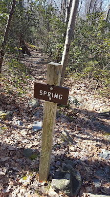
A little more climbing, and another road crossing: this time Rattlesnake Run Road, and finally you're into the main portion of the hike. The trail bears generally west until you crest the hill and come down the other side, and then turns north and descends slightly through a tunnel of green. This eventually leads you to a small clearing, and a sign for a spring. The spring was flowing fairly well, but was full of leaves.
 |
| Spring source, leaves floating on the water |
 |
| The spring is 30 yards beyond the sign |
From the spring, the trail turns again, continuing into the forest. The trail here is generally flat, with a few gradual ups and downs.
After about 2 miles, you come across the Deer Lick (Run) Shelters. There are two Adirondack-style shelters here, the openings face away from each other. There are also two tent pads behind the shelters. I didn't see any other tent pads. There is a spring up the hill in front of the shelters, which I believe forms Deer Lick Run, which you cross as you continue north on the trail.
 |
| Shelters from the trail |
 |
| Shelters from the "Spring" sign |
 |
| Shelter closeup |
 |
| Deer Lick Run |
Here the trail will gently climb, and you'll come across first a gas line cut, and then what is probably a fire road. Not long after this, the trail begins to descend into the valley toward Old Forge. It gets kind of steep at times, so step carefully. The trail eventually flattens out before another more gradual descent just before you reach Old Forge. You'll hear the sound of running water before you see the creek and footbridges. You'll cross two footbridges over two branches of Antietam Creek, which runs out of the Waynesboro Dam.
 |
| Crossing the gas line cut |
 |
| Crossing the gravel road |
 |
| Coming down from the ridge |
 |
| Bridge over Antietam Creek |
Continuing further along the trail, you'll cross another (probably gas line) cut in the trees, and then another footbridge, taking you toward the main part of the Old Forge picnic area. There's a small building which has a spigot/water tap. The sign said fresh water year round...but I didn't try it.
The Old Forge Picnic area has about 10-12 parking spaces, a couple of picnic shelters, and some vaguely historic-looking buildings. I'm sure there's more to the park, but I didn't do much exploring.
 |
| Water tap here |
 |
| Coming into the main area of the park |
 |
| Old church |
 |
| Parking |
A few more pics of Antietam Creek for your enjoyment...
As stated before, I did this hike and the previous one as out-and-backs. If you have a hiking partner, you could easily do both (Pen Mar to Old Forge) as a one-way, approximately 6.8-mile shuttle hike, leaving a car at Old Forge, and then driving to Pen Mar to begin the hike.
For my next hike, I'll probably start at Old Forge and keep exploring into Pennsylvania. Definitely need to knock out a section or two of Maryland as well.
Happy hiking!


No comments:
Post a Comment
Hello! Please leave your comments!
(All comments will be moderated, so if yours doesn't show up right away, please be patient.)