As I've said before, the Harpers Ferry area has become one of my favorite places to visit since I've moved to the East Coast. The view of Harpers Ferry and the confluence of the Potomac and Shenandoah Rivers from Maryland Heights is a wonder that everyone should see at least once. As the Potomac continues to meander its way through the gap it has carved in the Blue Ridge Mountains, it flows past another excellent vantage point: Weverton Cliff.
Weverton Cliff is located at the southern end of South Mountain in Maryland just off the Appalachian Trail. The trailhead is located at the end of Weverton Cliff road, a few yards from the parking lot- just a set of rock steps that disappear into the woods. The trail is very rocky, and winds up the hill via a series of switchbacks. In fact, I lost count of how many times the trail turned back on itself, but it makes the climb *much* easier. It's definitely a good workout, but not nearly as strenuous as the Maryland Heights hike, which is pretty much a straight climb.
The trailhead:
At times the path is quite narrow. This is also one of the few sections of trail that's generally free of large rocks.
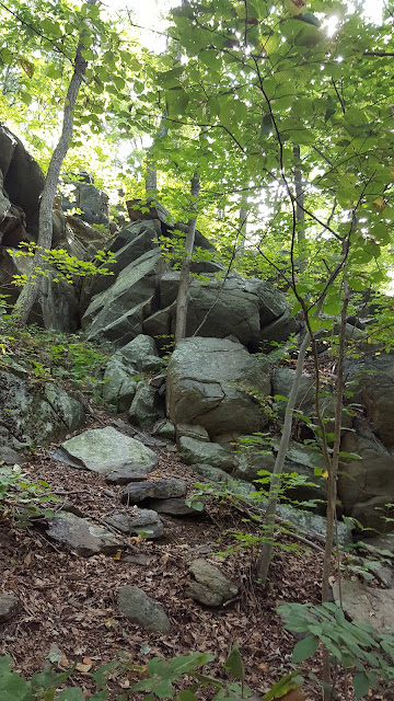
Big pile of rocks.
Very rocky trail, wear good boots with ankle protection, and use those trekking poles for balance and support!
When you reach the top of the hill, you'll come across a T-intersection with a sign post directing you toward the cliff or north on the AT. Unfortunately, the sign board pointing to Weverton Cliff was missing, but, as usual on the AT, follow a light blue blaze for side trails.
The trail to the cliff overlook takes you down the hill a bit.
Once at the overlook, you'll have to do some rock scrambling to get the best vantage point to take some really great pics. I only had my phone camera, but it worked pretty well...
You can see the bridge where US340 crosses the Potomac into Virginia, but without binoculars I could not discern Harpers Ferry at all. The ridge on the left is Loudon Heights, on the right is Maryland Heights and Elk Ridge. The Stone Fort, on Elk Ridge, might be more visible once the leaves have fallen.
Some kayakers were enjoying the beautiful weather on the river.
Back to the sign, headed down the hill...
After visiting the cliff, I traveled north on the AT for a short distance before turning around and heading back to the car. The AT continues a gradual climb heading north along the ridge. I was initially going to aim for the Ed Garvey Shelter as a turn-around point, but I got a late start and decided to head home.
Notes:
As usual, wear a good pair of hiking boots. The trail is very rocky, and there are plenty of opportunities to twist an ankle. Trekking poles are highly suggested for balance. The trail is dog friendly, and I saw lots of people with their dogs while on my hike. As always, keep your dog on a leash and clean up any messes. I would not recommend this hike for small dogs, or dogs that can overheat easily.How to get there:
Set your preferred GPS navigation system to Weverton Cliffs Parking Lot. From Eastern Maryland: Get on Interstate 70W, take the exit to US340 south, same as if you were going to Harpers Ferry. Look for signs for MD 67 towards Boonsboro. Take the MD 67 exit and keep right. Weverton Cliff road is the first right after the exit. The parking lot is on the right a few hundred yards down.
Note: parking is extremely limited, only about 22 spaces, although there were a few cars parked along the side of Weverton Cliff road when I returned from my hike. Highly recommend that you get an early start on a weekend day, but I imagine that parking on weekdays is likely much more open. An extreme alternative is to park at the Harpers Ferry parking lot, take the bus into downtown, and hike the 1.5 miles along the AT (and C&O Canal) to get to the trail head for Weverton Cliff.
Another option, if you've got a second hiker and car, is to visit the cliffs via a one-way 6+ mile shuttle hike from Gathland State Park south to Weverton Cliff. Park a car at the Weverton Cliff lot, and then you and your hiking partner can ride up to Gathland SP to start. At the end of the hike, shuttle the other driver to their car back at Gathland SP.
Another option, if you've got a second hiker and car, is to visit the cliffs via a one-way 6+ mile shuttle hike from Gathland State Park south to Weverton Cliff. Park a car at the Weverton Cliff lot, and then you and your hiking partner can ride up to Gathland SP to start. At the end of the hike, shuttle the other driver to their car back at Gathland SP.


No comments:
Post a Comment
Hello! Please leave your comments!
(All comments will be moderated, so if yours doesn't show up right away, please be patient.)