Catoctin Mountain Park
Catoctin Mountain Park is a National Park located in Frederick, Maryland, near the town of Thurmont. Catoctin Mountain is part of the Blue Ridge Mountains of the Appalachian Mountain Range. The land for Catoctin Mountain Park was purchased during the Great Depression and redeveloped into a recreation area by both the Works Progress Administration and the Civilian Conservation Corps. The area had previously been used for producing charcoal. The park is also the location of the Presidential Retreat, Camp David, although this area is obviously off limits to the public. The Catoctin Trail cuts through both parks. Its northern terminus is at the northwest end of Catoctin Park.Getting to Catoctin from the DC/Baltimore area is really quite easy. Take Interstate 70W, and then US Hwy 15 North. There will be plenty of signs along US 15. The road leading to the Visitor Center actually goes between the two parks, so you can take the same route for both parks. There's a fair amount of parking at Catoctin Visitor Center (which is past the park headquarters), but if the lot is full, you can drive up the park central road, for more parking up the mountain. The Visitor Center has a video display of the park map, showing the various trails and some pictures. It also gives you average hiking times and difficulty levels.
There are a number of trails in Catoctin Park, and most of them could be considered somewhat strenuous or challenging for an inexperienced hiker. So far we have hiked the Falls Nature Trail and the Thurmont Vista Trail. The Falls Nature trail runs parallel to the road between the parks and can be easily accessed from the Visitor Center Parking lot. The trail has some challenging parts, but it's not terribly difficult - a fair amount of ups and downs throughout. It eventually leads to Cunningham Falls, a 78 foot cascade and the largest waterfall in Maryland. You do have to cross the road, so be careful here.


The Thurmont Vista trail starts right behind the visitor center at 920 feet and goes up the mountain to an altitude of almost 1500 feet. The climb is pretty straightforward, as you just go UP until you come around the side of the mountain to Thurmont Vista. As you can see from the map, you can continue around to Wolf Rock and then to Chimney Rock.
Author's note: we did our hike on December 1, so the pictures don't really do the park much justice. I can assure you that the park looks much more inviting in the warmer months.
hiking up the Thurmont Vista trail

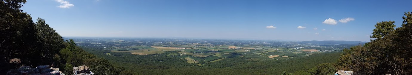
View from Thurmont Vista

there's a bench at the vista to take a well-deserved rest and enjoy the view.

looking back down the trail

Two things to watch out for, especially in warmer months: snakes and ticks. There are two species of poisonous snake that live in the park, the copperhead and the timber rattlesnake. Please use caution when moving about the rocks on the trails, and don't bother the snakes if you come across them. Combat ticks with a bug spray that will repel them, usually with DEET (follow instructions carefully). You can also purchase permethrin spray - you have to spray your clothing and allow it to dry (don't use it on skin!) and it will kill ticks on contact. (again, follow the instructions carefully) Other things you can do: Wear a hat, tuck your pants into your socks. You may look silly, but it's better than getting Lyme Disease. Wear light-colored clothing so the ticks can be spotted more easily. Make sure you do a thorough check when you get home.
Now that I've convinced you not to spend any more time in Catoctin... There are camping areas within Catoctin Mountain Park, and you can visit the park's website to find out more about them if you're thinking about spending a night or two.
Cunningham Falls Park
Cunningham Falls State Park, adjacent to Catoctin Mountain Park, offers more trails and recreational activities. There are two camping areas, the Houck and Manor Campgrounds. The Houck campground features a beach at Hunting Creek Lake. There's also two trails to get to Cunningham Falls, one is easy (the Lower trail), the other (Cliff Trail) is more strenuous- so you can take it easy on the way to or from the falls. The Cliff trail is very rocky and it is very easy to turn an ankle, so take your time and be sure of your footing.You reach the Falls on a boardwalk. However, many people ignore the signs and get into the small pool at the base of the falls to cool off. While this might sound nice, I don't condone it. Still others try to climb the falls, and I definitely don't recommend this. The falls aren't spectacular, except probably after heavy rains, but it's a nice feature to see regardless.


the Orange blaze shows the way


The Cliff trail runs concurrent with the Catoctin Trail for a short distance. Make sure you follow the Orange blaze!


Hope you enjoyed a small sampling of the pictures. Now go and take some of your own!


